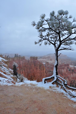
It started at 6:20 AM. The rain. Light and intermittent; no problem. By 7:30 AM we decided to get up and take advantage of a break in the rain to pack up our tent. It wasn't very cold; upper 30's, maybe. We drove outside the park to get breakfast. While eating, we noticed snow falling. The first snowfall of the season for this area! By the time we finished breakfast and began to drive back into the park, an inch had accumulated. And our campground in the park had a bit more than that! We're glad we packed up when we did. So when the snow flurries let up a bit we saw a few viewpoints in Bryce and then left for warmer areas. We drove through Escalante, Utah, through some beautiful canyons, over Boulder Mountain (9600 feet pass) where we stopped at many scenic viewpoints, and even saw some pretty aspen trees. Then we dropped down into lower elevations and drove through Capitol Reef National Park. To end the day we visited Goblin Valley State Park between Hanksville and Green River, Utah. Caren and I think for marketing purposes they should rename Goblin Valley as 'Shroom Valley'……many of the unique 'hoodoos' in this valley look more like mushrooms than 'goblins'. But the rock formations were interesting and we enjoyed a brief walk around the park. And here are some pictures from today! Enjoy!
Tuesday, October 26, 2010
Day 24: Page, Arizona to Bryce Canyon, National Park
We left Page and drove to Bitter Springs, AZ where we took a scenic alternate route through Marble Canyon and Lee's Ferry. Most interesting; beautiful red limestone cliffs; thousands of feet high. The bridge across the Colorado River at Lee's Ferry is about 400 feet above the river. One man fell to his death during the construction of it and four others quit the work after witnessing the fall into the river. There's a new bridge there now, built in 1995 but you can walk on the old bridge so we did. Then we drove through Fredonia, AZ and into Kanab, Utah. We drove through Zion National Park (twice) and then headed up to Bryce Canyon NP where we decided to stay inside the park at North Campground….about 7400 feet elevation. We did get to see a little of the main Bryce Canyon amphitheater at dusk. We turned in as the weather forecast was for rain showers to start sometime Monday AM and we were tired after a long day. Here are a few pictures.
Day 23: Williams, AZ to Page, AZ
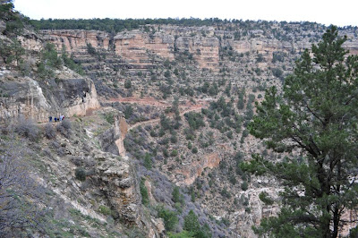
We did not get to the Grand Canyon by sunrise but that was by intent; the weather was rainy and was supposed to clear up a bit by 10:00 AM or so. Therefore we had a leisurely morning. Once at the Grand Canyon we parked the car and used the free shuttle buses to get around. We ended up hiking quite a bit; including down into the canyon a little (on Bright Angel Trail). Even though overcast, it did not rain and the canyon is really remarkable even without direct sun & shadows. Took lots of photos and look forward to culling them out and perhaps printing a few once we return home. Around 3:00 PM we left Grand Canyon Park and went to Cameron, AZ and had an excellent dinner consisting of Navaho tacos. I took a picture of Caren admiring a 15,000 dollar Navaho rug! We decided to stay in Page AZ for the evening and did catch a beautiful sunset along the drive from Cameron to Page.I've been reading a book I bought at the Grand Canyon, called 'Over the Edge: Death in Grand Canyon' which purports to list ALL of the known deaths that have occurred in Grand Canyon over the years….about 700 of them. Many of the stories are amazing; the twenty-year old who hopped over the guardrail to take a photo of something on the rim and while his eye was in the viewfinder stepped back to frame the photo and fell about 400 feet…..and the tragic story of a dad playing a joke on his teenage daughter by pretending to fall from the trail guardrail but then actually did…..and many others. The authors hope to analyze the causes of these deaths so as to help others avoid making mistakes in judgement. I am glad to report that we used excellent judgement and neither of us came close to falling over the edge. And that's without even having read the book! And here are a few of the day's pictures:
Friday, October 22, 2010
Day 22: Gallup, NM to Williams, AZ
A short drive. Showers off and on all day and we got a room in Williams then went the 50 miles north to the Grand Canyon. It was cold, drizzly and overcast when not raining. We had never seen the Grand Canyon under those conditions. I'm appending some pictures which we took. We plan to return and maybe hike a little into the canyon tomorrow. The weather forecast calls for improved conditions so we hope to see sunlight on the canyon walls. Under any conditions the canyon is an incredible sight.
Thursday, October 21, 2010
Day 21: Santa Rosa, NM to Gallup, NM
Only around 250 miles today; we started early enough due to the thunderstorm in Santa Rosa this morning. It began around 1:30 AM and the winds threatened to flatten our tent; then the lightning and thunder---so loud it made the ground (or at least, our air mattress) shake! It continued off and on again until we broke camp around 7:00 AM. We headed west to Albuquerque where we rode the aerial tram to the top of Mt. Sandia; at around 10,400 feet! There were some clouds at the top but we still enjoyed the ride and took photos. As we headed toward Gallup, we crossed the Continental Divide at around 7400 feet. Just past this point a tremendous thunderstorm dumped inches of hail on the ground leading to a very serious series of car wrecks; we were about 15 minutes behind these so we only got caught in the traffic snarl which resulted. But we passed the wreckage of a couple of vehicles and it looked very serious. More thunderstorms tonight and Gallup is around 6400 feet so we're not tenting it tonight. Tomorrow we should get to Williams, Arizona where we will spend at least one night & we plan to spend a day or two at the south rim of the Grand Canyon before going east and north to either the north rim of the canyon or to Zion National Park. We also want to visit Bryce and possibly the Arches national parks. Have gone 8000 miles on this trip so far! It's been great. Here are a few pictures:
Thunderstorm near Gallup, NM.
View from the tram to the top of the Sandia mountains near Albuquerque, NM
Looking down the east side of Sandia mountain where the ski slopes are located.
No 'trick' photography here; the clouds all had a bright outline and were an amazing sight.
Oncoming thunderstorm near the Continental Divide in New Mexico.
Thunderstorm near Gallup, NM.
View from the tram to the top of the Sandia mountains near Albuquerque, NM
Looking down the east side of Sandia mountain where the ski slopes are located.
No 'trick' photography here; the clouds all had a bright outline and were an amazing sight.
From the tram car.
Oncoming thunderstorm near the Continental Divide in New Mexico.
Subscribe to:
Comments (Atom)


